White Mountains – Samaria Gorge
Sekadakis Dimitris – Digenakis Nikos
Botonakis Ioannis – Michelakis Ioannis
6th Grade students
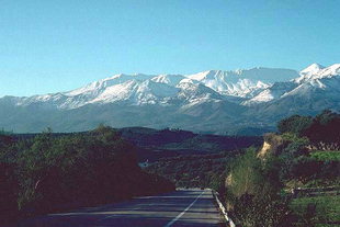 The White Mountains, or Mathares as are called by the locals, represent a real balcony above the Libyan and Cretan Sea. They are located in the middle of Chania Prefecture about 40km north from the city of Chania and are constituted of many high peaks. The highest one is “Pachnes” with an altitude of 2454m while there are other 20 peaks over 2200m. The Mountain covers a range of 750km2 - 30km width and 25km length. Many gorges and three plateaus are scattered in this area.
“Omalos” is the most well known plateau, located in an altitude of 1080m, about 40km far from the city of Chania, surrounded by the peaks “Volakias” (2216m), “Gigilos” (2081m.), “Samberos” (2005m) and “Psilafi” (1984m).
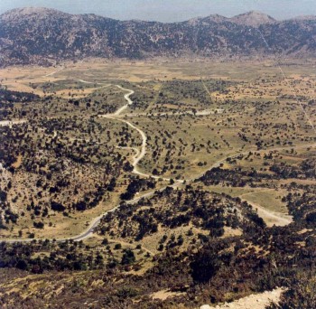
Some kilometers eastern are located Askifou plateau (730m), surrounded by “Castro” (2218m), “Tripali” (1493m) and “Agathes” (1511m) peaks. Its shape is conic and that is why it is called like that – “Skifos” in ancient Greek is a conic cup. The area has a great history. It was a victorious battlefield for the Greek Sfakian warriors against the Turks during the liberation revolution in 1821. Furthermore, it was in the homonymous village where the unification of Crete with Greek mainland was proclaimed in 1866.
The White Mountains, or Mathares as are called by the locals, represent a real balcony above the Libyan and Cretan Sea. They are located in the middle of Chania Prefecture about 40km north from the city of Chania and are constituted of many high peaks. The highest one is “Pachnes” with an altitude of 2454m while there are other 20 peaks over 2200m. The Mountain covers a range of 750km2 - 30km width and 25km length. Many gorges and three plateaus are scattered in this area.
“Omalos” is the most well known plateau, located in an altitude of 1080m, about 40km far from the city of Chania, surrounded by the peaks “Volakias” (2216m), “Gigilos” (2081m.), “Samberos” (2005m) and “Psilafi” (1984m).
Some kilometers eastern are located Askifou plateau (730m), surrounded by “Castro” (2218m), “Tripali” (1493m) and “Agathes” (1511m) peaks. Its shape is conic and that is why it is called like that – “Skifos” in ancient Greek is a conic cup. The area has a great history. It was a victorious battlefield for the Greek Sfakian warriors against the Turks during the liberation revolution in 1821. Furthermore, it was in the homonymous village where the unification of Crete with Greek mainland was proclaimed in 1866. 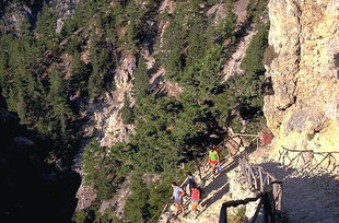 A bit higher is Tavri plateau and a kilometer further, at an altitude of 1200m is Niatos plateau.
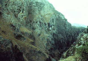
Crete is an island with many gorges. Some of the most awesome are in Chania. South you can find St. Irene Gorge in Selino Province, and some kilometers eastern in Sfakia Province are Aradaina Gorge and Imbros Gorge. But the most renown is Samaria Gorge. Samaria Gorge is declared a National Park since 1962 and many visitors come to cross it and admire its unique wild beauty. Reaching Omalos plateau and going across the road we end in the location “Ksiloskalo” – meaning wooden stair. This is the entrance of the Gorge in an altitude of 1081m and 43km far from Chania. From here you start your journey descending to the level of the sea in about 19km. Many years ago there was a wooden stair to help the descent of the gorge and the name still persists nowadays. Near the entrance is the church of St. Nikolas surrounded by high pine trees,
A bit higher is Tavri plateau and a kilometer further, at an altitude of 1200m is Niatos plateau.
Crete is an island with many gorges. Some of the most awesome are in Chania. South you can find St. Irene Gorge in Selino Province, and some kilometers eastern in Sfakia Province are Aradaina Gorge and Imbros Gorge. But the most renown is Samaria Gorge. Samaria Gorge is declared a National Park since 1962 and many visitors come to cross it and admire its unique wild beauty. Reaching Omalos plateau and going across the road we end in the location “Ksiloskalo” – meaning wooden stair. This is the entrance of the Gorge in an altitude of 1081m and 43km far from Chania. From here you start your journey descending to the level of the sea in about 19km. Many years ago there was a wooden stair to help the descent of the gorge and the name still persists nowadays. Near the entrance is the church of St. Nikolas surrounded by high pine trees, 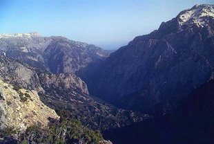 springs and clear waters. It is believed that in this location there was a sanctuary of Apollo the ancient Greek God of light near the ancient city Keno. Crossing the path of the gorge – Faraga as called by the locals – is a real challenge, an unprecedented experience. You find yourself confronted with the wild beauty of the nature. You cover a distance of 16km in the Gorge and another 3km to reach the village Agia Roumeli in the Libyan Sean. The average width of the Gorge is 20-30m with high precipitations from 500 to 800m.
 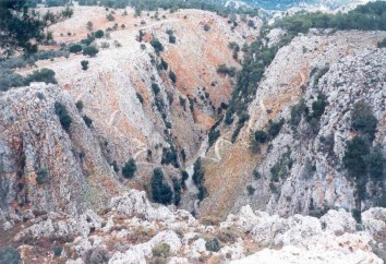 The narrowest spot “Portes” near the end of the Gorge has a width of 3m in between precipitations of 500m height. The hiker should were light clothes and shoes in order not to have many problems. The best month to pass the Gorge is in May. Despite the difficulties you encounter you are rewarded by marvelous scenery, a place with no human intervention, giving you a sense of amazement and impressive awe. The Gorge is named after a small church in the middle of the path, St. Mary's church. You are allowed to take photos but camping, fishing, swimming, lighting fires and smoking are not permitted. It is noteworthy that about 300,000 visitors come to pass the Gorge every year. As you finally complete your journey exhausted but full of experiences you reach at the coasts of the Libyan Sea in the village Agia Roumeli. The clear, crystal, blue waters of Libyan Sea will provide you with a refreshing, cold bath in order to complete your wonderful journey in the heart of White Mountains.